


Quick Adventure Facts:
Who - Joe (see gear list) & Matt (see gear list)
What - The Great Outdoors Challenge
When - May 9th to May 21st 2014 | 13 Days
Where - Plockton to St. Cyrus, Scotland | map, .gpx, .kml *
Trail Overview
Trail
The Great Outdoors Challenge isn’t a set trail but rather an event hosted by The Great Outdoors Magazine each year. It is a challenge, not a race, which involves crossing from the west coast of Scotland to the east coast on foot during a specific two week window.
Participation is limited to around 250-300 challengers each year.
LengthTGOC is a really unique event in that there is no defined route. There are many possible starting and end points. Challengers must create their own path on existing trails, jeep roads, and cross country through the Scottish highlands.
Scotland is a wide open country with few trees, so you can walk almost anywhere. You can even walk across private property legally in Scotland. The only limitation is your route must be vetted and approved to make sure it is safe and realistic. Practically no two routes are exactly the same, but you will still cross paths with many other challengers along the way.
The average route length is around 200 miles.
TerrainAs there is no set trail, there are no markers and you’ll have to follow your maps and GPS to make sure you’re on track. Most routes are a mix of trails, dirt roads, and cross country routes. The landscape is wide open with grass, soft shrubs, and 'peat hags' which are like muddy pits where the soft ground has eroded away.
The cross country sections allow you to walk almost anywhere you’d like frequency passing a fair amount of ruins, castles, and other historical landmarks including places like Loch Ness, Balmoral Castle and Fort William.
The ground is very wet and squishy most of the time. A fellow challenger suggested that “Scotland is not a country, but rather a giant sponge floating in the North Sea.”
WeatherMay in Scotland has notoriously crummy weather. A typical day might be between the 30's and 50's F, and it is often rainy or even snowy. Challengers should expect to be walking in 40F rain for two weeks with night times temperatures potentially dropping below freezing.
It can be really windy on the exposed peaks, and you need to be prepared to camp in those types of conditions.
Timing
The challenge takes place during the second and third weeks of May. This particular window of time was chosen as it usually comes after the last of the severe winter weather and before the annual infestation of the dreaded Scottish midges; nasty biting flies similar to mosquitoes.
Most of Scotland is sparsely populated and many of the starting and ending points are in fairly remote areas. Luckily, the train system in Scotland, as in the rest of the UK, is pretty awesome. Sometimes the train will stop at a bench in the middle of farmland to drop off or pick up a passenger.
The hardest part of TGOC is probably planning it. Since you have to create your own route it takes a fair amount of time pouring over maps, Google Earth, and prior year challenger's blogs. Planning your foul weather alternatives can prove to be the most difficult challenge for a lot participants.
Navigating can prove to be tricky as well as there are many times where you will find yourself hiking in dense fog with no ability to pick out landmarks. A GPS or navigation app on your phone can prove to be invaluable.
ResupplyDesigning your own route affords Challengers the ability to resupply as frequently as they’d like. Some routes stay low in valleys and can pass through villages every day. Other routes can venture through more remote areas with resupply taking place only once or twice per challenge. One of the best parts of the adventure is visiting quaint towns, and socializing with other challengers at the local pub or hostel.
GearA typical 3 season set up like Joe and Matt used will work well on for TGOC, maybe with some gear rain gear thrown in. You can check out Joe's gear list here and Matt's here.
Trip Report
By: Matthew Favero
I found myself deep down a rabbit hole after answering a customers email asking about how our gear would handle Scottish weather. They were going to be going to Scotland for an event called The Great Outdoor Challenge. Every May, Challengers plan a coast to coast walk across Scotland and then embark on a unique, choose your own adventure, crossing of the country.
I became obsessed as I kept researching and it didn’t take long before I vowed to do it myself. Joe was obviously down and so was our good friend Steve. We registered for the event in October, planned our route, bought our plane tickets and we were on our way.
We took an overnight flight to Glasgow and landed early in the morning. We took the bus into the middle of town and then changed our clothes in a Starbuck’s bathroom before heading to the post office to mail our street clothes to the end.
After our package was sent, we found a market to get some food before rushing to catch our train. Seeing the Scottish countryside by train is absolutely amazing. Everything is so green and the mountains are gorgeous. We switched trains in Inverness and then made our way to the seaside town of Plockton.
The weather was overcast and dreary and we were tired and hungry. We checked into our hostel by the train station and then headed out. The few shops around were closed for the afternoon; a kind of Scottish siesta. The first shop to open was a fish and chips shack. I don’t even fish but I was so hungry that I scarfed down a giant piece of fish!
After we ate, Joe and Steve headed back to the hostel and I went into an old pub to steal their wifi and relax. The pub filled with challengers and tourist as the night went on and it was fun to people watch in a new part of the world. The sun eventually began to set and I went back to the hostel to get some rest.
In the morning, we woke up and walked around looking for a place to eat. Eventually, a BnB let us in and served us a fantastic Scottish Breakfast. I was particularly impressed with the porridge and I must have drank 6 glasses of orange juice. The blood pudding though, not so much. After breakfast, we checked in to officially begin the challenge and we were on our way.
The trail followed along side the small bay that Plockton rests upon before ducking into the forest and following a beautiful path. It didn’t take long before we reached the highlands though. Within an hour we were climbing up wet and muddy hillsides to get to the top.
Eventually, we found ourselves in a thick forest. The trees were so tight that we had to push ourselves through them. For the better part of an hour we battled the trees until we finally made it to a road and then a jeep track.
The jeep track followed a river for quite a bit before we had to cross the river and climb over some peaks on the other side. We stayed up high for a bit before beginning a descent into a valley. On our way down, we had to hop some electrified fences. I caught my butt on the back of one and really got a good shock.
We finally made it to the road and followed it to the small village of Killilan. From there we made our way through some farm land before beginning a long steep climb. The weather starting moving in and we were forced to set up camp on uneven ground on the edge of the trail. I ate one of the pre-made sandwiches that I bought in Glasgow and went to bed.
When we woke up we were covered in fog. We could barely see 10 feet in front of us. We broke down camp and continued our climb from the day before. It didn’t take long for us to reach the summit of Sguman Coinntich. The wind was whipping and we couldn’t see much but we made it.
The weather started to clear as we made our way through the highlands and eventually dropped into a valley near the two houses that make up Carnach. We passed a huge herd of stag as we followed a road to an old hunting lodge to take a break.
From the lodge, we climbed up to a pass and made our way towards Loch Mullardoch before following a river up a valley. The sandwich from the night before really hadn’t agreed with me and I wasn’t feeling very well. I was feeling nauseous and the slow long climb was taking it out of me.
When we made it to the head of the valley, we had to climb over a steep ridge to get to another valley on the other side. Joe and Steve flew up the side of the while I struggled to keep pace. Once to the top, it started to sprinkle and we began our long decent down the valley. Knowing that we’d be setting up camp soon and having an easy descent helped pick up my spirits.
The trail spit us out into the beautiful scenery of Glen Affric. What an amazing place to set up camp! I set up my tent, struggled in vain to eat and then passed out in what was probably the most beautiful campsite that I’d ever slept it.
The weather was beautiful in the morning and we had the pleasure of walking up the glen for quite some time. It was so lush and green and the portion next to Loch Affric was simply stunning. About an hour and a half into the day, we came to our turn off, the Footpath to Cougie.
As soon as we left Glen Affric, the trail turned to straight mud. We found ourselves ankle to knee deep in mud for well over a mile as we slowly climbed up to a dirt road at the top of a ridge. On a map, Cougie looks sizable enough to have a small store where we could get a snack or a drink and we were excited to follow the road into the village.
When we finally arrived in Cougie, it was nothing more than a couple houses, a few horses and a ton of sheds. We couldn’t believe that all of those buildings on the map were just sheds. Who puts a shed on a map? The only thing to temper our disappointment were the small horses that were in a fenceless pasture. They came up to us and let us pet them but never crossed the stones on the ground that ringed the property.
After a short break, we continued on our way through more wet trail as we made our way back into the highlands. We were ahead of schedule when we descended down to a dirt road and decided to keep hiking instead of camping at our designated stop.
We followed a series of dirt roads pass lined with what seemed like hundreds of sheep before we started to see signs of civilization. We could see some farm houses in the distance and a busy road too. We knew that we couldn’t go too much further or we’d run out of a good place to camp. We passed a few farm houses before finding a small patch of forest to duck into. We hoped a fence, walked a hundred or so feet back into the forest and set up camp.
At this point, I hadn’t eaten a full meal since day one. I was merely operating on water and a few bites of the only thing I could keep down, Joe’s Chilli Heatwave Doritos. I wasn’t feeling very good but I was still moving. For some reason I began obsessing over the idea of orange juice.
I woke up excited that we would be getting to our first town by mid-day. We broke camp and started down the farm road just outside of the forest. We passed a few houses before making a turn and began a slow climb. It didn’t take long for us to make it to the top. Now it was all downhill into town.
The trail was mellow and easy to follow and we eventually made our way down to the main road. Excited we picked up the pace and started following alongside a river. About a mile down the road, we realized we were hiking in the wrong direction. Doh! We turned around in embarrassment and made our way towards Fort Augustus.
Soon we were on the outskirts of town and we came upon a hostel. We checked in, enjoyed the wifi while our room was being prepared and then dropped off our bags off. Hungry, we went into town. We came to a gas station and I ran inside and bought a quart of orange juice and pounded it right there in the parking lot. It was actually the worst orange juice I’ve ever had but it still tasted great.
Now that we had that covered we went and found a restaurant and had ourselves a proper meal. Venison burgers, haggis and more. We were starving and we all enjoyed a warm meal. After lunch we walked around through the tourist shops and pretended that we saw Nessie in the Loch before heading back to the hostel for a shower and some rest.
Later that evening, we went back into town to get some more supplies and feast yet again. It was so nice to be able to eat again and I was taking full advantage of it. My energy level was back to normal and so were my spirits. I was ready to attack the next the day as we headed back to the hostel to go to sleep.
The morning brought beautiful weather. It was clear and cool with no wind to be seen. We made our way out of town and began a gentle climb up a dirt road. A couple of hours into the day we stumbled across our first bothy and took a break. The UK has a network of old cabins, farmhouses and buildings that hikers can use to seek refuge from the elements called bothys.
After our break at the bothy, we continued on our way through the highlands. We had beautiful expansive views for the rest of the day and the wind gradually picked up speed. When we finally got to our camp spot, the wind was howling. We had trouble setting up our tents and need to use large boulders to keep our stakes in the ground. With our tents set up, we quickly got in to seek refuge.
Not twenty minutes after we set our tents up, the wind totally died. If we had just waited, we would have had such an easier time. We all laughed at our fortunes, ate dinner and passed out. The rest of the evening had nothing more than a gentle and calm breeze.
The next day picked up right where the pervious one left off. Beautiful weather and beautiful views dominated the majority of the day. We were up high all day and having a great time. Later in the day as we had just reached the top of a climb, we turned around and saw a menacing storm cloud heading our way.
The wind started to pick up and the storm clouds were really moving in. We decided to abandoned our route and take a side trail down the mountain to avoid the incoming weather. We found a dirt road and started running down the mountain. We stumbled upon a bothy and ran inside.
As soon as we got into the bothy a drop of rain hit the pane of glass on the window, followed by another and then another. There would be no more after that. We ran down the mountain and off route to avoid three rain drops! Regardless, we decided to stay put for the evening.
The bothy had a giant circular table in it that we joking referred to as the Knight Table. We all ate dinner at the table before blowing up our air mattresses and getting set up for bed. I decided to sleep on top of the table because, why not?
In the morning we continued to make our way down the mountain and ended up on a fairly busy road. We followed the road into the small town of Kingussie where we found a little convenience store and got some snacks before continuing on our way to Aviemore.
The roadwalk was long and boring and the cars passing at a high rate of speed weren’t very fun either. When we finally made it Aviemore, the very first building we saw was an Italian restaurant with an all you can eat buffet. We went into full hiker mode, raced passed the restaurant, found a hostel 200 yards later, checked in and then ran back to feast!
The restaurant had pizza, tons of pasta dishes and wifi. I was in heaven and I spend quite a bit of time stuffing my face. After plate upon plate of tasty food, we went back to the hostel to take a shower and chill out.
We all went out for dinner and found a quaint little pub with great food and great conversation. We strolled around the streets and found a market to resupply at before heading back to the hostel. I went back to the Italian restaurant, which was now closed, to steal some wifi and talk to my wife before heading back to catch some sleep.
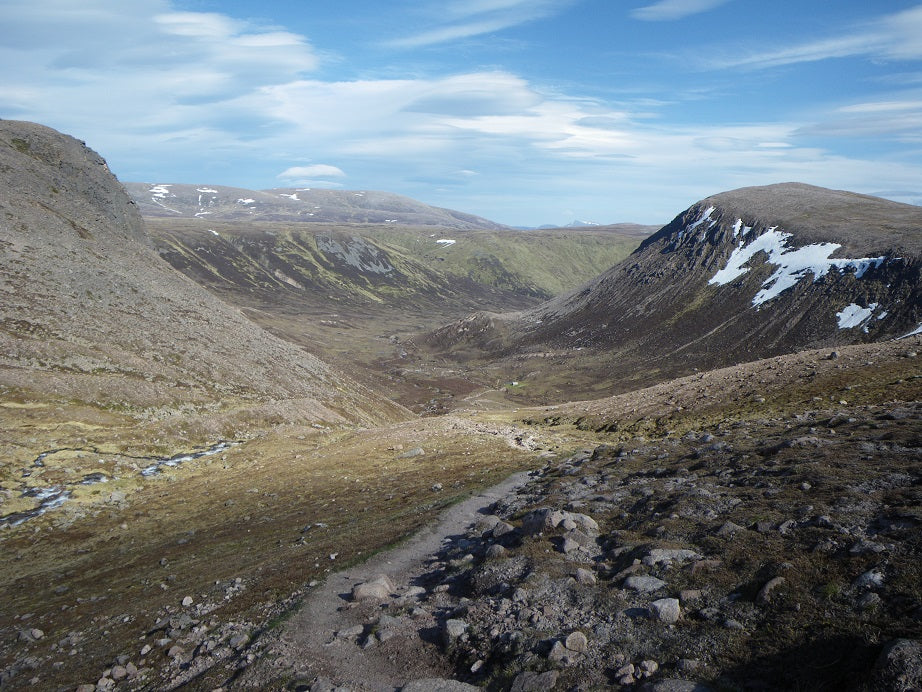
It didn’t take long to reach the Cairngorms in the morning. The outskirts of the park was pretty flat and easy going but we slowly started to climb and the wind really picked up. As we entered Lairig Ghru pass, the winds were howling. We left the pass and made our way up the steep side of the mountain.
The wind was relentless and we made our way up to the edge of the cliffs. When we finally made it to the top, we were being blown all over the place. The winds were over 50 mph sustained and it was like hiking in a hurricane on a sunny day. We continued climbing up towards the second highest peak in the UK, Ben Macdui.
The climb wouldn’t have been particularly hard if it wasn’t for the wind. We took refuge behind some wind breaks when we could find them before making our final push. Just below the peak, we had to climb up a steep snow field. One step forward, half a step back. The snow field finally gave way to the rocky peak and we had made it.
We took pictures, posed for others and relished our accomplishment. We didn’t linger for long though as the wind had become an annoyance at this point. As we started our descent down the back side of the mountain, the wind pick me up mid-stride and sent me tumbling into the rocks. Unhurt, I stood up and kept going.
When we got far enough down the mountain, the peak blocked the wind and the trail opened up to another huge snow field. We were running a few steps and then using our shoes as skis to slide for 8 to 10 feet. Having never hiked in snow before, I was having a pretty good time.
The snow gave way to more rocky trail just above Loch Etchachan before the trail made a sharp turn and a steep decent. We could see a small bothy in the distance where we were going to stay the night and I decided to slow down and enjoy the last bit of hiking for the day. A half an hour later I strolled into Hutchinson Memorial Hut to meet up with the others.
The bothy was really small and pretty cold. There was a single Brit inside who we’d share the bothy with that night. Joe slept on a bench and Steve and I slept on the ground. It wasn’t glamorous but it was shelter from the elements and for that we were grateful.
When we opened the bothy door in the morning is was absolutely gorgeous. The trail followed a tourist grade path down a long lush valley. We were making good time and the the views were beautiful. We stopped to take a break at Derry Lodge, an old shuttered hunting lodge before continuing on.
Not long after we left Derry Lodge we began to see signs for Mar Lodge saying that “Walkers were welcome.” The countless signs peaked our curiosity and we had to go and check it out. The signs lead us to a huge estate. It had amazing architecture and looked to be something right out of Downtown Abbey.
There was a backroom in the rear of the lodge where they had set up coffee and tea for Challengers. We sat with a group of jolly chaps from all over the UK as we sipped our drinks and enjoyed biscuits around the fireplace. We even had the chance to talk to some workers from the Cairngorm's about the wildlife and the possibility of reintroducing wolves to Scotland.
From Mar Lodge, we crossed the Victoria Bridge and then decided to follow the road into Braemar. The road walk followed along side a valley for a few miles before dumping us into the quaint little village. We looked for a place to stay and finally found a little bunkhouse off the beaten path. We dropped off our bags and then headed out to get some food.
We found a nice little cafe and had lunch before wandering around the town. We ran into a large group of Challengers who had congregated in the Fife Arms Hotel and had a good time making new friends and bantering. There was an older Scottish man playing piano in the main area and his rendition of “Country Road” was a huge hit. Hearing “West Virginia, Mountain Mama” in a Scottish accent was a real treat. :). We then headed back to the bunk house, took showers and then went to bed.
The next morning we took a nice forested trail out of Braemar that led to the “Lions Face.” There is a rock formation on the side of mountain that resembles a lions face if you look at it from a certain angle. We didn’t see it ourselves but we’ll take the locals word for it.
Eventually, we climbed under fence and were spit out onto a road. We followed the road for a few miles before crossing an old bridge and walking on some forest roads. We spent the majority of the day on these dirt paths winding through the forest, at one point seeing a herd of well over 100 stags.
The dirt paths gave way to small farm roads, one of which led us past Balmoral Castle. This is where the Queen of England stays in the summer. The grounds were pristine and well manicured and stumbling across this spot was a true treat.
The small roads took their time as they guided us to Ballater, as small town along the River Dee. We searched for a place to stay before finding a spot above a tavern. We headed back out and enjoyed a late lunch at a small cafe before resupplying and heading back to our rooms.
Joe and Steve went out for Indian food and I stayed back and took a long bath. It was good to relax and get some rest. The TV in my room wasn’t working and I took this as a sign. I decided to go to bed early and enjoy my time cuddled up in my blanket.
As soon as we crossed the bridge out of town in the morning, we started climbing. It didn’t take long before we found ourselves immersed in the fog at the top of the mountain. We could hardly see and needed to depend on my GPS to ensure that we stayed on track. At one point we passed an American coupled doing the Challenge heading in the opposite direction. That was probably a good sign that we were heading the wrong way.
Eventually the fog lifted and we continued to follow old dirt tracks through the highlands. The day turned out to be sunny and clear and the hiking was fairly enjoyable. We found a nice little spot in a tight valley to camp for the night. The small stream close to our site lulled us to sleep and the soft grass under our tents made for a fantastic nights rest.
The next day began with a step climb up the other side of the valley. Once to the top we followed a series of dirt paths to the edge of the highlands. The hills end abruptly on the east coast of Scotland and we could almost see the North Sea from the last high point.
We made our last long descent of the trip until we found ourselves surrounded by farmland and livestock. Weaving our way through country roads, we headed to the small village of Fettercairn in hopes of finding something to eat.
When we strolled into Fettercairn, there wasn’t much and what there was, was closed. We found a little shop that sold sandwiches and we kept the owner busy doing just that. The sandwiches were so good that we all went back in and ordered a second one.
While we were waiting for our sandwiches a guy came into the shop and very seriously said the most British thing ever; “Do you know two cheeky caps who drive a red convertible?” We all laughed inside, as this is something you’d never hear someone say in seriousness back home.
After lunch we continued down the small roads. We had a choice to make, hike another 15 miles and end a day early or look for the next good camp spot and give ourselves a relatively short day tomorrow. We decided to camp and kept our eyes out for the next good spot.
We eventually found one of the last few patches of forest left before we got to the coast. It went really deep back off of the road. The forest was so thick that even at 3pm, it looked like it was dusk inside. We sat around eating snacks and talking before heading to bed early. I must have slept 14 hours that night.
We were blessed with fantastic weather on our last day of the Challenge. It was clear and sunny and the temperature was amazing. We followed along small roads as we pieced together a haphazard route to the coast.
It only took a few of hours before we found ourselves walking into St. Cyrus. We found a beach access and made our way down the bluffs to the sea. We all dipped our toes in the North Sea before writing our names in the sand and Joe even went for a swim. The hike was officially over and it had been my longest to date. I felt such a sense of accomplishment and I was so happy to share it with my friends.
We made our way back up the bluff and had breakfast before taking a bus to Montrose to officially sign out. We got a spot at a little camp ground and then explored the town before heading back to the Park Hotel for the Challenger Banquet.
The banquet was full of Challengers and featured speeches, recognitions and delicious food. The camaraderie we felt at the banquet was like nothing else that I’ve ever experience before. It was one of the highlights of the trip and I highly suggest anyone participating in the event to attend the banquet.
*All provided navigation files are made available as a planning resource with the understanding that data is provided with no warranties, expressed or implied, concerning data accuracy, completeness, reliability, or suitability. Zpacks shall not be liable regardless of the cause or duration, for any errors, inaccuracies, omissions, or other defects in, or untimeliness or unauthenticity of, the Information, or for any delay or interruption in the transmission thereof to the user, or for any Claims or Losses arising therefrom or occasioned thereby. The end user assumes the entire risk as to the quality of the data.
