


Quick Adventure Facts:
Who - Joe (see gear list)
What - Continental Divide Trail Thru-hike
When - June 17th to November 17th 2009 | 154 Days
Where - Canada to Mexico | map, .gpx, .kml *
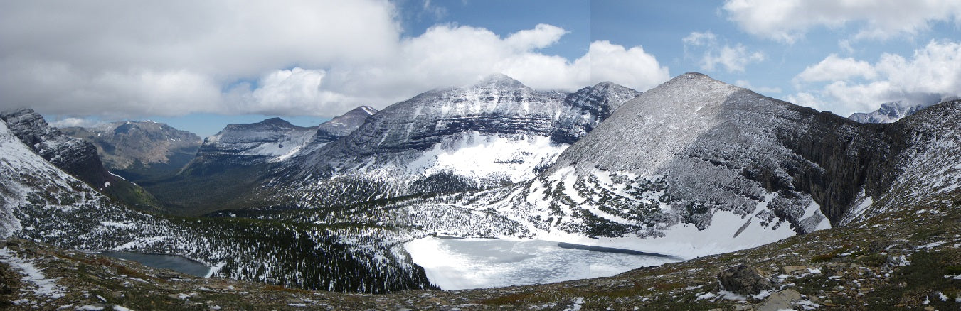
Trail Overview
Trail
For starters, the Continental Divide Trail is not a trail, it is a route. Maybe it is not even a route but more of an idea.
There are multiple acceptable places to start at the Canadian Border, and multiple acceptable places to end at the Mexican border.
The trail itself is a connection of existing trails, jeep tracks, goat paths, and cross country traverses that attempts to roughly follow the Continental Divide through the Rocky mountains from Canada to Mexico. The divide itself is the ridge where water on one side flows to the Pacific Ocean, and water on the other side flows to the Atlantic via the Gulf of Mexico.
You might think of the CDT like a Choose your own Adventure book. Technically there might be an "official route" but I can assure you that no one has ever followed it exactly. There is a semi-official route described in Jim Wolf's CDT guidebooks, and several routes and alternatives on the Jonathan Ley CDT maps. Almost every single day on the CDT you are presented with choices of where to go. For example one route might go cross-country up and over a high mountain peak, and another route might ford a river 15 times while following a lower valley trail. Sometimes the routes separate for a few miles and reconnect, other times they can separate for 100's of miles before joining back up. If you tried you could probably hike the CDT twice with very little overlap.
Due to the nature of the CDT much of it is not marked and you must rely on your maps, compass, and the Wolf guide books to find your way. There will be many times when you aren't 100% sure exactly where you are, and that is just fine.
The important thing in my opinion is that you walk a continuous path every single step from Canada to Mexico.
The CDT spans approximately 3,100 miles (5,000 km) across 5 states follows the divide from Mexico to Canada.
TerrainThe CDT can be pretty challenging. It depends on which routes you take, but it can often involve steep scrambling up and down mountainsides, climbing over miles of downed trees, and following treacherous ravines or avalanche zones. You will ford more rivers in one day than on the entire AT and PCT combined. You may hike for days through snow storms, or across miles of feet-deep snow from last year's snow pack. If you injure yourself on certain off-trail sections of the CDT there is a good chance no one will ever find you. You could choose routes that are not as balls-to-the-wall but what fun is that? As they say on the CDT "Embrace the Brutality".
The CDT has scenery that is as good or better than the PCT but you may have to work 10x harder for it.
You need to be prepared for rain storms, snow storms, and frigid weather on the CDT can be unpredictable. It can snow every single month from June to November and it can rain or storm at any time. You can get hail and lightning and insane winds. Sometimes it is nice. :)
Timing
The CDT can be walked Northbound or Southbound. Southbound hike you start at the Montana/Canada Border in Glacier National Park. Hikers generally start in mid to late June to allow enough snow to melt off the mountain trails and passes. You have to move right along though or you will not make it through the San Juan mountains in Colorado before the snows start in late September. The trail finishes at the New Mexico / Mexican boarder. A Southbound thru-hike can be extremely cold in some sections.
A Northbound hike is warmer than going South. However most Northbound hikers go around or skip the San Juan Mountains because they are too snowed in in the spring. They have to move quickly to reach Glacier Park before it gets snowed in in September.
Most hikers take 5 to 6 months to finish their thru-hike.
LogisticsThe CDT is one of the hardest trails to do. Both of the termini are in remote areas and require days of travel for most people to access.
Since the trail is not a single defined route or many markers it requires a lot of navigational skill. Maps and compasses on the trail are a necessity. Many sections are cross-country or the trail might be buried under snow. Relatively few hikers do the CDT (and those who do may take different routes) so you can be completely alone for long stretches. Many sections are very remote. You will often find yourself misplaced and backtrack.
It's not a bad idea carry a GPS, SPOT or maps on your phone.
Resupply is generally 4-6 days between towns, and you will have to do some food mail-drops to places that do not have stores. The longest section of my hike was 9 days through the Wind River range in Wyoming.
Water sources are scarce and unreliable in New Mexico. Our longest section between water was about 40 miles. We were only expecting that particular section to be 25 miles but a well was dry.
Compared to the AT or PCT, you should add in an extra cold weather layer like a winter hat, maybe a Patagonia thermal weight base layer, and SealSkinz waterproof socks for hiking in the snow. You should upgrade to a 5F sleeping bag rather than a typical 20F.
Trip Report
By: Joe Valesko
I started hiking on June 17th in Glacier National Park Montana. There was packed snow on the ground frequently for the first week or so through Glacier and into the Bob Marshall Wilderness. I crossed Triple Divide pass in a white out blizzard that dumped a half foot of snow on June 22nd. I hiked for 21 days completely alone before meeting my first long distance hiker.
The weather was nice through southern Montana and Idaho, but there were constant swarms of mosquitoes all the way south to Yellowstone, Wyoming in August.
The Wind River range in central Wyoming was spectacular, with glaciers and fresh snow. Night time temperatures hit the teens there on August 15th in the middle of the summer. The mosquitoes finally disappeared.
The Red Desert in southern Wyoming was flat and barren with almost no shade whatsoever. Daytime highs hit the 90s and water was scarce or gross.
My wife Sheryl joined me in Rawlins, WY on August 24th about half way through the trail. I had been hiking solo prior to this.
Colorado started great on September 1st. The mountains were huge, the weather nice, and the aspens golden.
Snow started falling on September 21st midway through Colorado and nighttime temps got cold.
In the San Juan mountains of southern Colorado we were nailed with several blizzards. We broke trail through a foot to waist deep snow for days at a time. Night time temperatures hit the single digits, and some days the temperature never went above freezing. Only five southbound thru-hikers including Sheryl and I made it through the San Juans without bailing out or going around that year. Only a couple north-bounders that I know of made it through in the spring.
The CDT is not an easy trail. By comparison, it probably only snowed once or twice each on the AT and PCT, and never went below 20F.
The weather improved almost overnight at the New Mexico border on October 15th. We had a few lingering snow showers, but mostly sunny skies, and easy cruising all the way to Mexico. Water was scarce again in the desert, sometimes 30-35 miles apart but the cool November temperatures made it easier to travel with little water.
We finished at the Mexican border on November 17th, 2009 with a huge group of 16 hikers, which is a rare crowd for the CDT. Samurai Joe (myself), Hellfire (Sheryl), Brett, Bree, Freefall, Agent Orange (George), Luna, Chance, SoFar, Valley Girl, Panda, Brian, Brenda, Max Relax (Mike), Patch, and Tooth Fairy all completed together. Beacon, and The Gimp also finished ahead of the group south bound that year. That list of 18 hikers was pretty much the entire class of southbound thru-hikers in 2009. The CDT can be a lonely trail if you want it to be, but we had a great time with alot of camaraderie on the second half of our hike.
*All provided navigation files are made available as a planning resource with the understanding that data is provided with no warranties, expressed or implied, concerning data accuracy, completeness, reliability, or suitability. Zpacks shall not be liable regardless of the cause or duration, for any errors, inaccuracies, omissions, or other defects in, or untimeliness or unauthenticity of, the Information, or for any delay or interruption in the transmission thereof to the user, or for any Claims or Losses arising therefrom or occasioned thereby. The end user assumes the entire risk as to the quality of the data.
